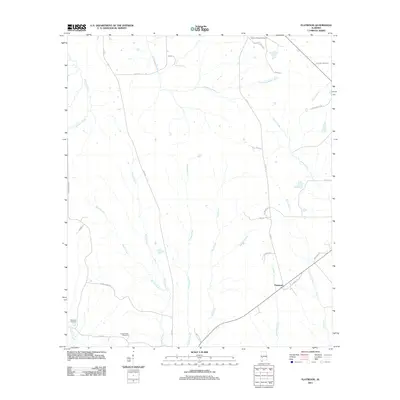
2011 Map of Flatwood
USGS Topo · Published 2011About this map
Flatwood serves as the primary settlement hub in this rural Marengo County landscape, situated at the junction of several local routes. The area is defined by a dense network of watercourses, including the prominent Chickasaw Bogue and Michigan Creek to the north, and Red Creek to the southeast. For those researching local lineages, the map identifies three significant burial grounds: Sidney Chapel Cemetery in the northeast corner, Mormons Cemetery in the southwest near Goose Creek, and Goose Creek Cemetery just to the east. The terrain is crisscrossed by established thoroughfares like Co RD 53 and Co RD 14, providing a clear view of the rural road network and settlement patterns in the early 21st century. The density of named creeks, such as Bokok Creek, Martin Creek, and Mud Creek, suggests a landscape shaped by its drainage into the nearby Black Warrior River basin.
Find a feature on this map
33 named features on this map. Tap any name to fly to it.
Don’t see what you’re looking for? This feature index may not catch every label — zoom into the map to look around manually.
Map Details
Editions of this 2011 Flatwood Map
This is the sole edition of this map. No revisions or reprints were ever made.
Other maps of this area

1953 · Montgomery
USGS Topo · 1:250,000

1956 · Montgomery
USGS Topo · 1:250,000

1957 · Montgomery
USGS Topo · 1:250,000

1968 · Thomaston East
USGS Topo · 1:24,000

1968 · Thomaston West
USGS Topo · 1:24,000

1968 · Central Mills
USGS Topo · 1:24,000

1974 · Catherine
USGS Topo · 1:24,000
1974 · Lee Long Bridge
USGS Topo · 1:24,000

1978 · Surginer
USGS Topo · 1:24,000
1978 · Flatwood
USGS Topo · 1:24,000