
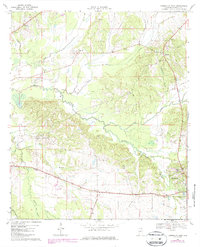
1968 Map of Thomaston West
USGS Topo · Published 1971About this map
Dayton and Thomaston anchor the eastern edge of this Black Belt landscape, where the Louisville and Nashville railroad cuts a diagonal path across the southern terrain. This era in Marengo County shows a transition between traditional agriculture and modern infrastructure, evidenced by the proximity of the State Prison Camp and Linden Airfield to historic rural centers. The map preserves the locations of several community landmarks, including the County Training Sch and the curiously named settlement of Half Chance.
Find a feature on this map
37 named features on this map. Tap any name to fly to it.
Don’t see what you’re looking for? This feature index may not catch every label — zoom into the map to look around manually.
Map Details
Editions of this 1968 Thomaston West Map
2 editions found
Other maps of this area

1953 · Montgomery
USGS Topo · 1:250,000

1956 · Montgomery
USGS Topo · 1:250,000

1957 · Montgomery
USGS Topo · 1:250,000

1968 · Thomaston East
USGS Topo · 1:24,000

1968 · Uniontown West
USGS Topo · 1:24,000

1968 · Gallion
USGS Topo · 1:24,000

1970 · Old Spring Hill
USGS Topo · 1:24,000

1970 · Linden
USGS Topo · 1:24,000
1978 · Flatwood
USGS Topo · 1:24,000
1978 · Miller
USGS Topo · 1:24,000