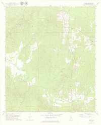
1978 Map of Miller
USGS Topo · Published 1979About this map
Miller serves as a focal point in this Marengo County landscape during the late 1970s, situated within a dense network of creek drainages that define the local geography. The area's social fabric is anchored by several rural congregations and their burial grounds, such as Bethlehem Ch, Bethlehem Cem, and Berry Chapel Cem. The settlement pattern follows the ridges between water bodies like Beaver Creek and Wilson Creek, with small communities such as Octagon and Calvary connected by secondary roads. A notable geographic feature in the eastern section is Marengo Lake, while the topography to the west is carved by numerous smaller tributaries including Cane Creek and Turkey Branch. This survey provides a clear look at the transitional nature of this Alabama landscape, where scattered settlements and timberlands meet at the intersection of several townships.
Find a feature on this map
28 named features on this map. Tap any name to fly to it.
Don’t see what you’re looking for? This feature index may not catch every label — zoom into the map to look around manually.
Map Details
Editions of this 1978 Miller Map
This is the sole edition of this map. No revisions or reprints were ever made.
Other maps of this area

1953 · Montgomery
USGS Topo · 1:250,000

1956 · Montgomery
USGS Topo · 1:250,000

1957 · Montgomery
USGS Topo · 1:250,000

1968 · Thomaston West
USGS Topo · 1:24,000

1970 · Myrtlewood North
USGS Topo · 1:24,000

1970 · Linden
USGS Topo · 1:24,000

1978 · Surginer
USGS Topo · 1:24,000

1978 · Sweet Water
USGS Topo · 1:24,000
1978 · Nanafalia
USGS Topo · 1:24,000
1978 · Myrtlewood South
USGS Topo · 1:24,000