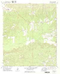
1978 Map of Nanafalia
USGS Topo · Published 1979About this map
Nanafalia and Sweet Water anchor this rural landscape in Marengo County, reflecting a settlement pattern deeply tied to the creek networks of southwest Alabama. The topography is defined by the winding paths of Sweetwater Creek and Horse Creek, which flow through a region marked by numerous small communities and family landmarks. This 1978 survey highlights the social fabric of the era through its concentration of local institutions, including the St Paul Ch, Holiness Ch, and the Independent Ch.
Find a feature on this map
32 named features on this map. Tap any name to fly to it.
Don’t see what you’re looking for? This feature index may not catch every label — zoom into the map to look around manually.
Map Details
Editions of this 1978 Nanafalia Map
2 editions found
Other maps of this area

1953 · Montgomery
USGS Topo · 1:250,000

1953 · Andalusia
USGS Topo · 1:250,000

1953 · Hattiesburg
USGS Topo · 1:250,000

1953 · Meridian
USGS Topo · 1:250,000

1956 · Montgomery
USGS Topo · 1:250,000

1957 · Meridian
USGS Topo · 1:250,000

1957 · Montgomery
USGS Topo · 1:250,000

1957 · Andalusia
USGS Topo · 1:250,000

1958 · Hattiesburg
USGS Topo · 1:250,000

1965 · Meridian
USGS Topo · 1:250,000