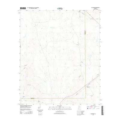
2014 Map of Flatwood
USGS Topo · Published 2014About this map
Flatwood lies at the intersection of rural life and the natural waterways of western Alabama, positioned along the border between Marengo Co and Wilcox Co. The landscape is defined by an intricate network of creeks and branches, including the prominent Chickasaw Bogue and Bokok Cr. For genealogists and local historians, the presence of several established burial grounds provides significant research value, with Sidney Chapel Cem located in the northeast, Goose Creek Cem situated along the southern border near Goose Cr, and Mormons Cem positioned in the southwest. Transport through this creek-crossed terrain is managed by a mix of state routes and county roads, such as Al-5, Al-28, and Bokok Creek Rd, which link the scattered residences and family lands that have historically occupied this corner of the Alabama Black Belt.
Find a feature on this map
42 named features on this map. Tap any name to fly to it.
Don’t see what you’re looking for? This feature index may not catch every label — zoom into the map to look around manually.
Map Details
Editions of this 2014 Flatwood Map
This is the sole edition of this map. No revisions or reprints were ever made.
Other maps of this area

1953 · Montgomery
USGS Topo · 1:250,000

1956 · Montgomery
USGS Topo · 1:250,000

1957 · Montgomery
USGS Topo · 1:250,000

1968 · Thomaston East
USGS Topo · 1:24,000

1968 · Thomaston West
USGS Topo · 1:24,000

1968 · Central Mills
USGS Topo · 1:24,000

1974 · Catherine
USGS Topo · 1:24,000
1974 · Lee Long Bridge
USGS Topo · 1:24,000

1978 · Surginer
USGS Topo · 1:24,000
1978 · Flatwood
USGS Topo · 1:24,000