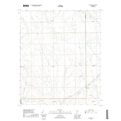
2018 Map of Flatwood
USGS Topo · Published 2018About this map
The borderlands of Marengo and Wilcox Counties define this rural Alabama landscape, centered on the settlement of Flatwood. The area is characterized by an intricate network of waterways, including the winding Chickasaw Bogue and various creeks like Michigan Cr and Little Red Creek. These drainage patterns have historically influenced local movement and settlement, as evidenced by the distribution of family and community landmarks. Genealogists and local historians can find several burial grounds within this quadrangle, such as Sidney Chapel Cem near Sidney Chapel Rd, as well as Mormons Cem and Goose Creek Cem. Transportation in the region is anchored by Al Highway 5, which connects the scattered homesteads and agricultural plots to the broader county infrastructure, while local routes like Old Airport Rd and Bokok Creek Rd provide access to the more secluded reaches of the timberlands and creek bottoms.
Find a feature on this map
48 named features on this map. Tap any name to fly to it.
Don’t see what you’re looking for? This feature index may not catch every label — zoom into the map to look around manually.
Map Details
Editions of this 2018 Flatwood Map
This is the sole edition of this map. No revisions or reprints were ever made.
Other maps of this area

1953 · Montgomery
USGS Topo · 1:250,000

1956 · Montgomery
USGS Topo · 1:250,000

1957 · Montgomery
USGS Topo · 1:250,000

1968 · Thomaston East
USGS Topo · 1:24,000

1968 · Thomaston West
USGS Topo · 1:24,000

1968 · Central Mills
USGS Topo · 1:24,000

1974 · Catherine
USGS Topo · 1:24,000
1974 · Lee Long Bridge
USGS Topo · 1:24,000

1978 · Surginer
USGS Topo · 1:24,000
1978 · Flatwood
USGS Topo · 1:24,000