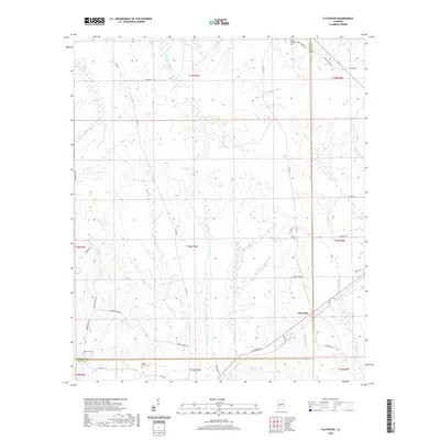
2020 Map of Flatwood
USGS Topo · Published 2020About this map
Chickasaw Bogue and its numerous tributaries, including Graham Cr and Bokok Cr, dominate this landscape at the intersection of Marengo and Wilcox counties. This area of Alabama is defined by a complex network of small waterways and drainage basins, such as Mud Cr and Little Red Cr, which likely shaped the early settlement patterns of Flatwood. The land is divided by several historical township and range boundaries, reflecting the structured land management of the Deep South.
Find a feature on this map
50 named features on this map. Tap any name to fly to it.
Don’t see what you’re looking for? This feature index may not catch every label — zoom into the map to look around manually.
Map Details
Editions of this 2020 Flatwood Map
This is the sole edition of this map. No revisions or reprints were ever made.
Other maps of this area

1953 · Montgomery
USGS Topo · 1:250,000

1956 · Montgomery
USGS Topo · 1:250,000

1957 · Montgomery
USGS Topo · 1:250,000

1968 · Thomaston East
USGS Topo · 1:24,000

1968 · Thomaston West
USGS Topo · 1:24,000

1968 · Central Mills
USGS Topo · 1:24,000

1974 · Catherine
USGS Topo · 1:24,000
1974 · Lee Long Bridge
USGS Topo · 1:24,000

1978 · Surginer
USGS Topo · 1:24,000
1978 · Flatwood
USGS Topo · 1:24,000