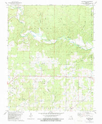
1979 Map of Flatwoods
USGS Topo · Published 1986About this map
The Little Black River winds through this section of the Ozark foothills, defining the rural character of the Flatwoods area. The map illustrates a landscape shaped by narrow hollows and numerous springs, such as Big Spring Hollow and the distinctive King Bee Spring. This mid-1970s survey reveals a community deeply rooted in its local institutions, evidenced by the high density of country churches and family burial grounds scattered across the terrain. From Spring Hill Ch in the center to Pilgrims Rest Ch further east, these landmarks serve as anchor points for the surrounding farmsteads. Local water access is highlighted by the Greenville Ford Public Access, while the complex drainage of the region is traced through features like Caldwell Creek and Buzzard Run. This map offers a detailed view of the Missouri-Arkansas border region before modern development altered these traditional settlement patterns.
Find a feature on this map
33 named features on this map. Tap any name to fly to it.
Don’t see what you’re looking for? This feature index may not catch every label — zoom into the map to look around manually.
Map Details
Editions of this 1979 Flatwoods Map
2 editions found
Other maps of this area

1934 · Williamsville
USGS Topo · 1:48,000

1935 · Acorn
USGS Topo · 1:62,500

1939 · Doniphan
USGS Topo · 1:62,500

1940 · Williamsville
USGS Topo · 1:62,500

1940 · Naylor
USGS Topo · 1:62,500

1944 · Naylor
USGS Topo · 1:62,500

1944 · Grandin
USGS Topo · 1:62,500

1945 · Doniphan
USGS Topo · 1:62,500

1946 · Grandin
USGS Topo · 1:62,500

1957 · Poplar Bluff
USGS Topo · 1:250,000