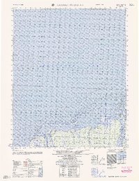
1962 Map of Flaxman Island A-1
USGS Topo · Published 1962About this map
The Hulahula River and Okpilak River flow into the Arctic waters shown here, illustrating a remote coastline defined by shifting deltas and offshore shoals. Compiled from 1950s aerial photography and coastal hydrography, this area shows a landscape largely untouched by permanent settlement, with Anderson Point providing one of the few named landmarks along the Camden Bay shoreline. A notable Tractor Trail cuts across the tundra parallel to the coast, indicating the difficult nature of overland transport in this northern environment before more permanent infrastructure. Waterways like the Katakturuk River and Nularvik River snake through the coastal plain, feeding into the Beaufort Sea near features such as Arey Island. The map records essential hydrographic data for navigators, including depth soundings and the locations of extensive sand shoals.
Find a feature on this map
12 named features on this map. Tap any name to fly to it.
Don’t see what you’re looking for? This feature index may not catch every label — zoom into the map to look around manually.
Map Details
Editions of this 1962 Flaxman Island A-1 Map
This is the sole edition of this map. No revisions or reprints were ever made.
Other maps of this area

1951 · Barter Island
USGS Topo · 1:250,000

1951 · Demarcation Point
USGS Topo · 1:250,000

1951 · Mt. Michelson
USGS Topo · 1:250,000

1955 · Flaxman Island
USGS Topo · 1:250,000

1955 · Demarcation Point
USGS Topo · 1:250,000

1955 · Flaxman Island A-1
USGS Topo · 1:63,360

1955 · Mount Michelson D-2
USGS Topo · 1:63,360

1955 · Barter Island A-5
USGS Topo · 1:63,360

1955 · Mount Michelson D-1
USGS Topo · 1:63,360

1955 · Demarcation Point D-5
USGS Topo · 1:63,360