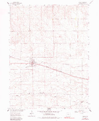
1962 Map of Fleming
USGS Topo · Published 1983About this map
Fleming serves as the central hub of this High Plains landscape in Logan County, where the Burlington Northern railroad cuts a straight diagonal line across the prairie. The town site is well-defined with local infrastructure including an Athletic Field, Water Tank, and Storage Bins, reflecting its role as a grain-handling and community center. To the northwest, the Fleming Cem stands near the town limits, providing a key point of interest for genealogical research.
Find a feature on this map
14 named features on this map. Tap any name to fly to it.
Don’t see what you’re looking for? This feature index may not catch every label — zoom into the map to look around manually.
Map Details
Editions of this 1962 Fleming Map
3 editions found
Other maps of this area

1953 · Tamarack Ranch
USGS Topo · 1:24,000

1953 · Crook
USGS Topo · 1:24,000

1953 · Proctor
USGS Topo · 1:24,000

1954 · Sterling
USGS Topo · 1:250,000

1958 · Sterling
USGS Topo · 1:250,000

1962 · Fleming
USGS Topo · 1:24,000

1962 · Uhler Ranch
USGS Topo · 1:24,000

1962 · Haxtun West
USGS Topo · 1:24,000

1972 · St Petersburg
USGS Topo · 1:24,000

1972 · Rockland
USGS Topo · 1:24,000