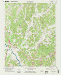
1973 Map of Flener
USGS Topo · Published 1974About this map
The Green River carves through the southern corner of this landscape, marking a vital waterway punctuated by Mile 135 and Mile 139. Several small communities and rural centers like Baizetown, Dexterville, and Flener are linked by a network of winding roads, while the Western Kentucky Pkwy provides a modern corridor through the western hills. The social fabric of the era is visible in its numerous houses of worship and education, including Mt Zion Ch, Flener Chapel, and the Fifth District Sch.
Find a feature on this map
41 named features on this map. Tap any name to fly to it.
Don’t see what you’re looking for? This feature index may not catch every label — zoom into the map to look around manually.
Map Details
Editions of this 1973 Flener Map
2 editions found
Other maps of this area

1909 · Hartford
USGS Topo · 1:62,500

1911 · Dunmor
USGS Topo · 1:48,000

1914 · Little Muddy
USGS Topo · 1:62,500

1914 · Dunmor
USGS Topo · 1:62,500

1925 · Spring Lick
USGS Topo · 1:62,500

1953 · South Hill
USGS Topo · 1:24,000

1954 · Evansville
USGS Topo · 1:250,000

1954 · Horton
USGS Topo · 1:24,000

1954 · Spring Lick
USGS Topo · 1:24,000

1954 · Welchs Creek
USGS Topo · 1:24,000