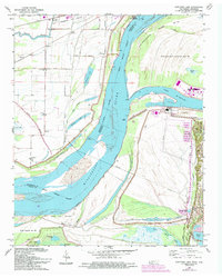
1966 Map of Fletcher Lake
USGS Topo · Published 1993About this map
Chucalissa Archaeological Park and Fuller State Park anchor the eastern bluff overlooking a complex riverine environment where the Mississippi River defines the border between Tennessee and Arkansas. The mid-1960s landscape is a study in industrial and agricultural transition, showing the Allen Generating Plant and a network of pipelines alongside established landholdings like the Ensley Plantation. The map reveals the critical role of water management in the region, dominated by the massive St Francis Levee and a system of drainage ditches like Ditch No 19 that protect settlements such as Wyanoke and Waverly. Genealogists will find particular value in the distribution of community centers like New Salem Ch and Lake Grove Ch, along with the St John Cem, which mark the social fabric of these rural riverfront townships before late-century expansion altered the topography.
Find a feature on this map
59 named features on this map. Tap any name to fly to it.
Don’t see what you’re looking for? This feature index may not catch every label — zoom into the map to look around manually.
Map Details
Editions of this 1966 Fletcher Lake Map
4 editions found
Other maps of this area

1908 · Lake Cormorant
USGS Topo · 1:24,000

1912 · Lake Cormorant
USGS Topo · 1:31,680

1916 · Memphis
USGS Topo · 1:62,500

1925 · Memphis
USGS Topo · 1:48,000

1927 · Memphis
USGS Topo · 1:62,500

1931 · Horseshoe Lake
USGS Topo · 1:62,500

1932 · Horn Lake
USGS Topo · 1:48,000

1935 · Horn Lake
USGS Topo · 1:62,500

1939 · Horseshoe Lake
USGS Topo · 1:62,500

1939 · Edmondson
USGS Topo · 1:62,500