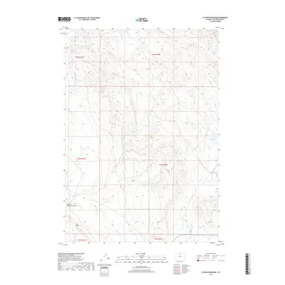
2017 Map of Flitner Reservoir
USGS Topo · Published 2017About this map
Flitner Reservoir sits at the northern edge of this high-elevation landscape in Big Horn County, a region defined by the water management systems necessary for ranching and agriculture in the Wyoming basin. This 2017 survey details the complex network of intermittent drainages and human-made improvements, including Walters Reservoir and the Anita Ditch, which redirect the flow from seasonal sources like Springs Cr and Alkali Cr. The terrain is dominated by the prominent rise of Blue Ridge in the southwest, sloping toward the deeply incised East Fork McDermotts Gulch. The map provides a clear look at the Public Land Survey System grid, documenting the township and range boundaries that have organized this territory since its early settlement. It serves as a precise record of the modern hydrological footprint in a landscape where water rights and access remain central to the local economy.
Find a feature on this map
14 named features on this map. Tap any name to fly to it.
Don’t see what you’re looking for? This feature index may not catch every label — zoom into the map to look around manually.
Map Details
Editions of this 2017 Flitner Reservoir Map
This is the sole edition of this map. No revisions or reprints were ever made.
Other maps of this area

1955 · Sheridan
USGS Topo · 1:250,000

1958 · Sheridan
USGS Topo · 1:250,000

1960 · White Sulphur Spring
USGS Topo · 1:24,000

1960 · Flitner Reservoir
USGS Topo · 1:24,000

1960 · Hyatt Ranch
USGS Topo · 1:24,000

1960 · Manderson NE
USGS Topo · 1:24,000
1960 · Bush Butte
USGS Topo · 1:24,000

1960 · Manderson SE
USGS Topo · 1:24,000

1962 · Sheridan
USGS Topo · 1:250,000
1967 · Hyattville
USGS Topo · 1:24,000