
1960 Map of Manderson SE
USGS Topo · Published 1962About this map
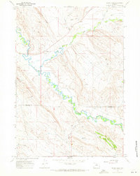
The Nowood River meanders through the southern portion of this landscape, supported by man-made irrigation infrastructure like the Shafer Ditch. This 1960 field survey reveals a terrain defined by extensive drainage systems and dry gulches, where the flatlands of Basin Flats meet the rising elevations of East Blue Ridge. The presence of several Oil Wells and a Drill Hole in the central and northern sections points to the region's mid-century energy exploration, while numerous bench marks such as BM 4138 and BM 4034 provide precise points for historic land surveying. Seasonal watercourses like Alkali Creek, Blue Fork, and Wild Horse Draw carve through the arid Wyoming geography, connected by a network of unimproved roads and a Jeep Trail that reflect the area's isolation and reliance on rugged transportation.
Find a feature on this map
17 named features on this map. Tap any name to fly to it.
Don’t see what you’re looking for? This feature index may not catch every label — zoom into the map to look around manually.
Map Details
Editions of this 1960 Manderson SE Map
This is the sole edition of this map. No revisions or reprints were ever made.
Other maps of this area

1955 · Sheridan
USGS Topo · 1:250,000

1958 · Sheridan
USGS Topo · 1:250,000

1960 · White Sulphur Spring
USGS Topo · 1:24,000

1960 · Manderson
USGS Topo · 1:24,000

1960 · Flitner Reservoir
USGS Topo · 1:24,000

1960 · Manderson NE
USGS Topo · 1:24,000

1960 · Wild Horse Flats
USGS Topo · 1:24,000

1962 · Sheridan
USGS Topo · 1:250,000
1967 · Weintz Draw
USGS Topo · 1:24,000
1967 · Mc Dermotts Butte
USGS Topo · 1:24,000