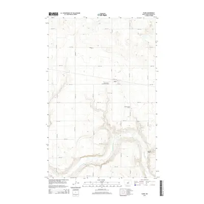
2014 Map of Flora
USGS Topo · Published 2014About this map
The Sheyenne River meanders across the southern landscape of this Benson County survey, cutting a distinct path through the North Dakota plains. The small community of Flora remains the focal point of the area, supported by a network of rural roads such as 37th St NE and 55th Ave NE. The map documents the persistent agricultural and aviation character of the region, featuring the Sabbe Brothers Landing Strip Airport and Gilbertson Field Airport. Local heritage is anchored by the presence of Maddock Cem and Flora Cem, which provide valuable points of reference for genealogists. To the east, the terrain is shaped by Peterson Coulee, illustrating the subtle yet significant drainage patterns that define this prairie environment.
Find a feature on this map
25 named features on this map. Tap any name to fly to it.
Don’t see what you’re looking for? This feature index may not catch every label — zoom into the map to look around manually.
Map Details
Editions of this 2014 Flora Map
This is the sole edition of this map. No revisions or reprints were ever made.
Other maps of this area

1932 · Flora
USGS Topo · 1:62,500

1943 · Maddock
USGS Topo · 1:62,500

1945 · Maddock
USGS Topo · 1:62,500

1951 · Flora SE
USGS Topo · 1:24,000

1951 · Black Hammer Hill
USGS Topo · 1:24,000

1951 · Flora
USGS Topo · 1:24,000

1951 · Josephine
USGS Topo · 1:24,000

1951 · Maddock
USGS Topo · 1:24,000
1951 · Hamberg
USGS Topo · 1:24,000

1951 · Flora
USGS Topo · 1:62,500