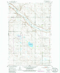
1951 Map of Flora SE
USGS Topo · Published 1986About this map
The Sheyenne River and West Sheyenne River wind through the prairie landscape of Wells, Benson, and Eddy counties, reflecting the agricultural and conservation priorities of mid-century North Dakota. Surveyed as part of the Department of the Interior's Missouri River Basin development program, this map captures a rural township structure defined by small community hubs like Valhalla and Grandfield. The presence of a National Waterfowl Production Area highlights the importance of the local wetlands within the migratory flyway.
Find a feature on this map
19 named features on this map. Tap any name to fly to it.
Don’t see what you’re looking for? This feature index may not catch every label — zoom into the map to look around manually.
Map Details
Editions of this 1951 Flora SE Map
2 editions found

Other maps of this area

1931 · Oberon
USGS Topo · 1:62,500

1932 · Flora
USGS Topo · 1:62,500

1948 · New Rockford
USGS Topo · 1:62,500

1948 · Cathay
USGS Topo · 1:62,500

1948 · Bremen
USGS Topo · 1:24,000

1949 · Bremen
USGS Topo · 1:24,000

1949 · Munster
USGS Topo · 1:24,000

1950 · New Rockford
USGS Topo · 1:24,000

1950 · Oberon SW
USGS Topo · 1:24,000

1950 · Oberon
USGS Topo · 1:62,500