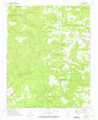
1973 Map of Floral
USGS Topo · Published 1975About this map
Floral sits at the eastern edge of this 1970s survey, where the hills of Independence Co meet a landscape of deep hollows and high ridges. The map reveals a community defined by its topography, with family-named features like Warren Mountain and Wideman Mountain rising above the winding drainage of Big Creek. This era shows a rural network of small country churches and cemeteries, such as Banner Ch and Moore Cem, which often served as the social and genealogical anchors for local residents.
Find a feature on this map
43 named features on this map. Tap any name to fly to it.
Don’t see what you’re looking for? This feature index may not catch every label — zoom into the map to look around manually.
Map Details
Editions of this 1973 Floral Map
2 editions found
Other maps of this area

1890 · Batesville
USGS Topo · 1:125,000

1891 · Batesville
USGS Topo · 1:125,000

1935 · Bald Knob
USGS Topo · 1:62,500

1942 · Jamestown
USGS Topo · 1:31,680

1942 · Almond
USGS Topo · 1:31,680

1953 · Memphis
USGS Topo · 1:250,000

1956 · Memphis
USGS Topo · 1:250,000

1962 · Pangburn
USGS Topo · 1:24,000

1963 · West Pangburn
USGS Topo · 1:24,000

1965 · Pleasant Plains
USGS Topo · 1:24,000