
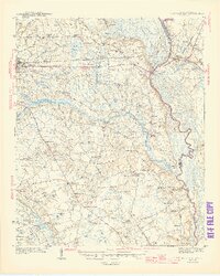
1945 Map of Florence East
USGS Topo · Published 1945About this map
The Pee Dee River and Lynches River frame this landscape of the South Carolina Coastal Plain during the mid-1940s. Following a survey by F. W. Cook and team, the map captures a rural economy defined by the Atlantic Coast Line and Seaboard Air Line railroads, which facilitated movement between the growing hub of Florence and smaller agricultural junctions like Pamplico and Effingham. The interior is heavily marked by "bays" and swamps, such as Gregg Bay and Polk Swamp, which dictated the placement of early settlements and crossroads.
Find a feature on this map
111 named features on this map. Tap any name to fly to it.
Don’t see what you’re looking for? This feature index may not catch every label — zoom into the map to look around manually.
Map Details
Editions of this 1945 Florence East Map
2 editions found
Other maps of this area

1940 · Florence West
USGS Topo · 1:62,500

1940 · Florence East
USGS Topo · 1:62,500

1943 · Gum Swamp
USGS Topo · 1:62,500

1945 · Florence West
USGS Topo · 1:62,500

1946 · Hyman
USGS Topo · 1:62,500

1946 · Lake City
USGS Topo · 1:62,500

1946 · Johnsonville
USGS Topo · 1:62,500

1947 · Friendship
USGS Topo · 1:24,000

1947 · Marion
USGS Topo · 1:24,000

1949 · Georgetown
USGS Topo · 1:250,000