Loading...
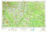
Loading map...1953 Map of Florence
USGS Topo · Published 1976About this map
Florence and Lumberton anchor a sprawling landscape defined by the drainage basins of the Pee Dee River and Lumber River. This mid-century survey, updated in the 1970s, captures the rail-dependent economy of the Carolina coastal plain as the Seaboard Coast Line and Atlantic Coast Line networks connected timber and agricultural hubs. The eastern portion of the sheet reveals a unique geological and ecological profile, characterized by the Carolina Bays — elliptical depressions such as White Lake, Singletary Lake, and Jones Lake St Pk.
Find a feature on this map
84 named features on this map. Tap any name to fly to it.
Don’t see what you’re looking for? This feature index may not catch every label — zoom into the map to look around manually.
Map Details
Date Portrayed1953
Date Published1976
PublisherU.S. Geological Survey
Map TypeTopographic
Scale1:250,000
Physical Dimensions32 x 22 inches
Editions of this 1953 Florence Map
3 editions found

Historical Maps of Fayetteville Through Time
3 maps found


Featured Locations
Source Details
SourceU.S. Geological Survey
CopyrightPublic Domain