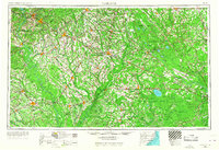
1953 Map of Florence
USGS Topo · Published 1967About this map
The Pee Dee River and Lumber River basins dominate this mid-century landscape, illustrating the complex hydrology of the Carolina borderlands before modern interstate expansion. Major rail corridors like the Atlantic Coast Line RR and Seaboard Air Line RR define the settlement patterns of regional hubs such as Florence, Lumberton, and Laurinburg. The map reveals a heavily forested interior, preserved within the Sand Hills State Forest and Bladen Lakes State Forest, contrasting with the concentrated agricultural and transit activity along U.S. 301 and U.S. 74. To the southeast, the massive Green Swamp and the waters of Lake Waccamaw represent significant natural landmarks. This 1:250,000 scale survey captures the rural character of the Carolinas during a period when small market towns like Tabor City, Elizabethtown, and Dillon remained vital railroad and highway junctions.
Find a feature on this map
82 named features on this map. Tap any name to fly to it.
Don’t see what you’re looking for? This feature index may not catch every label — zoom into the map to look around manually.
Map Details
Editions of this 1953 Florence Map
3 editions found

Other maps of this area

1909 · Coharie
USGS Topo · 1:62,500

1920 · Mayesville
USGS Topo · 1:48,000

1921 · Mayesville
USGS Topo · 1:62,500

1937 · Nixonville
USGS Topo · 1:48,000

1940 · Florence West
USGS Topo · 1:62,500

1940 · Florence East
USGS Topo · 1:62,500

1941 · Spartanburg
USGS Topo · 1:250,000

1942 · Troy
USGS Topo · 1:125,000

1942 · Burgaw
USGS Topo · 1:62,500

1942 · Nixonville
USGS Topo · 1:62,500