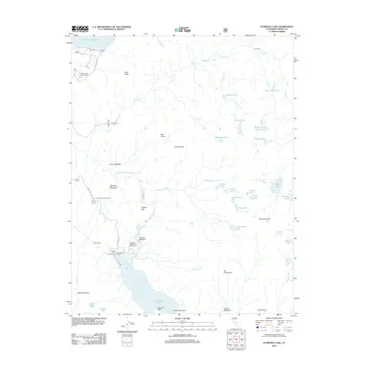
2012 Map of Florence Lake
USGS Topo · Published 2012About this map
Florence Lake Resort serves as a primary hub for recreation in this high Sierra landscape, situated near the western edge of Florence Lake. This 2012 survey illustrates a complex hydraulic and recreational network, featuring the Ward Tunnel and a series of campgrounds such as Jackass's Meadows Campground and Ward Lake Campground. The S Fork San Joaquin River and Hooper Cr drain a terrain marked by distinctive geological formations like The Tombstone, Jackass Dike, and Bear Dome. Meadow systems including Hell Hole Meadow and Poison Meadow interrupt the granite ridges, while high-altitude basins hold numerous named waters such as Crazy Lake, Foolish Lake, and Rose Lake. The presence of Kaiser Pass Rd provides the main artery through the area, linking these remote camps and trailheads.
Find a feature on this map
55 named features on this map. Tap any name to fly to it.
Don’t see what you’re looking for? This feature index may not catch every label — zoom into the map to look around manually.
Map Details
Editions of this 2012 Florence Lake Map
This is the sole edition of this map. No revisions or reprints were ever made.
Other maps of this area

1904 · Kaiser
USGS Topo · 1:125,000

1912 · Mt. Goddard
USGS Topo · 1:125,000

1947 · Mariposa
USGS Topo · 1:250,000

1948 · Mariposa
USGS Topo · 1:250,000

1953 · Mt Abbot
USGS Topo · 1:62,500

1953 · Huntington Lake
USGS Topo · 1:62,500

1953 · Blackcap Mtn
USGS Topo · 1:62,500

1953 · Kaiser Peak
USGS Topo · 1:62,500

1957 · Mariposa
USGS Topo · 1:250,000
1962 · Blackcap Mtn
USGS Topo · 1:62,500