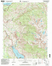
2004 Map of Florence Lake
USGS Topo · Published 2007About this map
Florence Lake and Lake Thomas A Edison anchor this high-elevation landscape in the Sierra National Forest during the early 2000s. The map captures a sophisticated network of water management and recreational infrastructure, including the Vermilion Valley Dam and several gaging stations. The John Muir Wilderness Ferry provides transit across Florence Lake, connecting remote backcountry routes with the Florence Lake Resort. This region is a critical node for long-distance hikers, where the Pacific Crest National Scenic Trail and the John Muir Trail converge near Jackass Meadows. Interpretive details show a landscape of granite and water, defined by landmarks like Bear Ridge, Mount Hooper, and The Tombstone. The presence of the Bear Diversion 4WD Route and other specialized tracks highlights the area's dual use for utility maintenance and wilderness access.
Find a feature on this map
70 named features on this map. Tap any name to fly to it.
Don’t see what you’re looking for? This feature index may not catch every label — zoom into the map to look around manually.
Map Details
Editions of this 2004 Florence Lake Map
This is the sole edition of this map. No revisions or reprints were ever made.
Other maps of this area

1904 · Kaiser
USGS Topo · 1:125,000

1912 · Mt. Goddard
USGS Topo · 1:125,000

1947 · Mariposa
USGS Topo · 1:250,000

1948 · Mariposa
USGS Topo · 1:250,000

1953 · Mt Abbot
USGS Topo · 1:62,500

1953 · Huntington Lake
USGS Topo · 1:62,500

1953 · Blackcap Mtn
USGS Topo · 1:62,500

1953 · Kaiser Peak
USGS Topo · 1:62,500

1957 · Mariposa
USGS Topo · 1:250,000
1962 · Blackcap Mtn
USGS Topo · 1:62,500