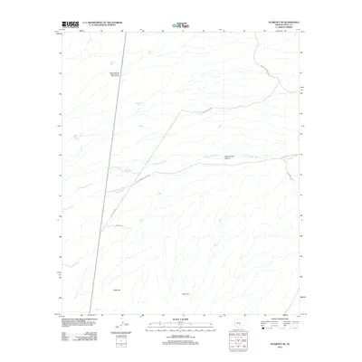
2011 Map of Florence NE
USGS Topo · Published 2011About this map
Arizona Highway Department Oil Storage Tanks sit along a remote highway stretch in this arid section of Pinal County, where the landscape is defined by drainage washes and livestock water management. The terrain is structured around Magma Wash and the winding Cottonwood Creek, which cuts through Cottonwood Canyon in the eastern portion of the quadrangle. High points like Black Hill and Dozer Hill rise above a network of utility and access corridors, including Gas Line Rd and Mineral Mountain Rd. A distinctive pattern of cattle tanks, such as Mormon Tank, Superior Tank, and El Molino Tank, reveals how this desert environment was utilized for ranching, with these small water features serving as essential landmarks in a largely unpopulated territory.
Find a feature on this map
21 named features on this map. Tap any name to fly to it.
Don’t see what you’re looking for? This feature index may not catch every label — zoom into the map to look around manually.
Map Details
Editions of this 2011 Florence NE Map
This is the sole edition of this map. No revisions or reprints were ever made.
Other maps of this area

1900 · Florence
USGS Topo · 1:125,000

1902 · Florence
USGS Topo · 1:125,000

1948 · Superior
USGS Topo · 1:62,500

1948 · Picketpost Mtn
USGS Topo · 1:24,000

1949 · Picketpost Mtn
USGS Topo · 1:24,000

1954 · Mesa
USGS Topo · 1:250,000

1956 · Magma
USGS Topo · 1:24,000
1956 · Superstition Mts. SW
USGS Topo · 1:24,000

1957 · Mesa
USGS Topo · 1:250,000

1958 · Mesa
USGS Topo · 1:250,000