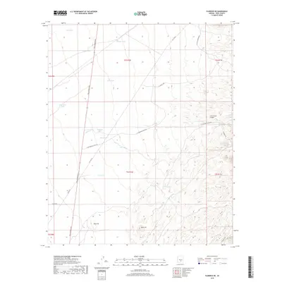
2018 Map of Florence NE
USGS Topo · Published 2018About this map
Pinal Pioneer Pkwy cuts a deliberate vertical line through this desert landscape of Pinal County, serving as the primary corridor through a region defined by its reliance on water catchment. The land is punctuated by numerous artificial basins such as Superior Tank, Twin Tanks, and Deep Well Tank, reflecting the essential infrastructure needed for ranching and resource management in this arid environment. To the east, the topography becomes more complex as it rises toward Cottonwood Canyon, where Cottonwood Cr and Magma Wash drain the higher elevations. Significant landmarks like Black Hill and Dozer Hill provide vertical relief among the network of utility and access roads, including Gas Line Rd and N Mineral Mountain Rd. This area illustrates the late 20th-century intersection of modern transportation routes with traditional desert land use patterns.
Find a feature on this map
27 named features on this map. Tap any name to fly to it.
Don’t see what you’re looking for? This feature index may not catch every label — zoom into the map to look around manually.
Map Details
Editions of this 2018 Florence NE Map
This is the sole edition of this map. No revisions or reprints were ever made.
Other maps of this area

1900 · Florence
USGS Topo · 1:125,000

1902 · Florence
USGS Topo · 1:125,000

1948 · Superior
USGS Topo · 1:62,500

1948 · Picketpost Mtn
USGS Topo · 1:24,000

1949 · Picketpost Mtn
USGS Topo · 1:24,000

1954 · Mesa
USGS Topo · 1:250,000

1956 · Magma
USGS Topo · 1:24,000
1956 · Superstition Mts. SW
USGS Topo · 1:24,000

1957 · Mesa
USGS Topo · 1:250,000

1958 · Mesa
USGS Topo · 1:250,000