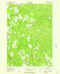
1955 Map of Florence
USGS Topo · Published 1957About this map
Florence and the surrounding borderlands of Lewis and Oneida counties are defined by a heavily forested landscape transitioning through mid-century reforestation efforts. In this era, small rural crossroads and hamlets like Empeyville, Thompson Corners, and Forty Six Corners remain connected by a network of unimproved roads and jeep trails. The hydrology is dominated by the Salmon River in the north and the complex drainage of Florence Creek, Cobb Brook, and the Mad River to the south.
Find a feature on this map
49 named features on this map. Tap any name to fly to it.
Don’t see what you’re looking for? This feature index may not catch every label — zoom into the map to look around manually.
Map Details
Editions of this 1955 Florence Map
Other maps of this area

1903 · Orwell
USGS Topo · 1:62,500

1905 · Orwell
USGS Topo · 1:62,500

1905 · Taberg
USGS Topo · 1:62,500

1906 · Highmarket
USGS Topo · 1:62,500

1906 · Kasoag
USGS Topo · 1:62,500

1942 · Redfield
USGS Topo · 1:24,000

1943 · Redfield
USGS Topo · 1:31,680

1943 · Westdale
USGS Topo · 1:31,680

1943 · Camden West
USGS Topo · 1:31,680

1943 · East Florence
USGS Topo · 1:31,680