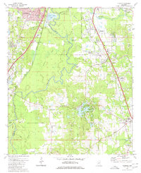
1980 Map of Florence
USGS Topo · Published 1980About this map
The Pearl River carves a winding path through the center of this landscape, defining the boundary between Hinds and Rankin counties. Significant meanders like Wansley Bend and the presence of Steamboat Bayou highlight the river's dynamic nature before it reaches the industrial outskirts of Jackson. This period of the late 1970s shows the suburban expansion of Richland and Florence along the Gulf Mobile and Ohio and Illinois Central Gulf rail corridors. Local heritage is preserved in smaller sites like McGowen Cem and Smith Cem, while the rugged topography of Tucker Bluff provides a natural contrast to the expanding sewage disposal ponds and sandpits that dot the region. The map captures a mix of rural transition, with landmarks like Frenchs Store sitting near modern trailer parks and a sprawling golf course near Cleary.
Find a feature on this map
53 named features on this map. Tap any name to fly to it.
Don’t see what you’re looking for? This feature index may not catch every label — zoom into the map to look around manually.
Map Details
Editions of this 1980 Florence Map
2 editions found
Other maps of this area

1903 · Jackson
USGS Topo · 1:125,000

1905 · Jackson
USGS Topo · 1:48,000

1906 · Florence
USGS Topo · 1:62,500

1908 · Jackson
USGS Topo · 1:62,500

1908 · Florence
USGS Topo · 1:62,500

1934 · Raymond
USGS Topo · 1:48,000

1937 · Raymond
USGS Topo · 1:62,500

1937 · Terry
USGS Topo · 1:48,000

1942 · Raymond
USGS Topo · 1:62,500

1943 · Terry
USGS Topo · 1:62,500