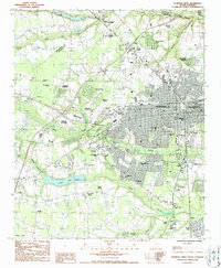
1986 Map of Florence West
USGS Topo · Published 1987About this map
Florence expanded westward during the late twentieth century, showing a transition from rural agricultural land to a complex suburban and industrial landscape. The western edge of the city is defined by significant institutional footprints, including the McLeod Regional Med Center and the Florence-Darlington Technical College. Settlement patterns are anchored by established residential pockets such as Grove Park and Windsor Forest, while older rural nodes like Hoffmeyer Crossroads remain distinct.
Find a feature on this map
56 named features on this map. Tap any name to fly to it.
Don’t see what you’re looking for? This feature index may not catch every label — zoom into the map to look around manually.
Map Details
Editions of this 1986 Florence West Map
2 editions found
Other maps of this area

1940 · Florence West
USGS Topo · 1:62,500

1940 · Florence East
USGS Topo · 1:62,500

1943 · Gum Swamp
USGS Topo · 1:62,500

1945 · Florence East
USGS Topo · 1:62,500

1945 · Florence West
USGS Topo · 1:62,500

1953 · Florence
USGS Topo · 1:250,000

1954 · Florence
USGS Topo · 1:250,000

1963 · Darlington East
USGS Topo · 1:24,000

1963 · Darlington West
USGS Topo · 1:24,000
1972 · Witherspoon Island
USGS Topo · 1:24,000