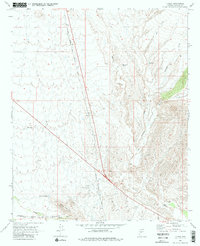
1969 Map of Flores
USGS Topo · Published 1980About this map
The Atchison Topeka and Santa Fe railroad serves as the primary corridor through this Yavapai County landscape at the end of the 1960s, bisecting the region near the settlement of Flores. The terrain is defined by a network of drainage systems including Antelope Creek, Martinez Creek, and Weaver Creek, which flow toward the south and west. Arid-land water management is evident through numerous features like Martinez Tank, Big Tank, and Pitts Tank, essential for ranching or local industry in this environment.
Find a feature on this map
18 named features on this map. Tap any name to fly to it.
Don’t see what you’re looking for? This feature index may not catch every label — zoom into the map to look around manually.
Map Details
Editions of this 1969 Flores Map
3 editions found
Other maps of this area

1887 · Prescott
USGS Topo · 1:250,000

1892 · Prescott
USGS Topo · 1:250,000

1903 · Congress
USGS Topo · 1:125,000

1904 · Congress
USGS Topo · 1:125,000

1947 · Wagoner
USGS Topo · 1:62,500

1948 · Wagoner
USGS Topo · 1:63,360

1950 · Wagoner
USGS Topo · 1:62,500

1950 · Prescott
USGS Topo · 1:250,000

1954 · Prescott
USGS Topo · 1:250,000

1954 · Phoenix
USGS Topo · 1:250,000