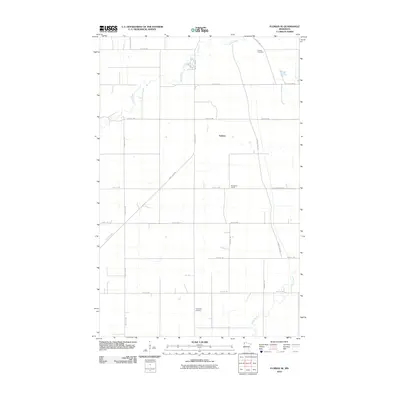
2010 Map of Florian SE
USGS Topo · Published 2010About this map
The community of Foldahl anchors this corner of Marshall County, situated within a landscape defined by the meandering courses of the Middle River and the Snake River. The map preserves the footprint of rural civic life, from the Woodland School to the Foldahl Cemetery in the northeast and the Township Cemetery to the south. Historically significant corridors intersect here, including the diagonal path of the Great Eastern and the Pembina Trl, which follow earlier patterns of movement across the prairie. The rigid grid of the Public Land Survey System is evident in the numbered road network, which provides access to the agricultural lands between the river basins.
Find a feature on this map
23 named features on this map. Tap any name to fly to it.
Don’t see what you’re looking for? This feature index may not catch every label — zoom into the map to look around manually.
Map Details
Editions of this 2010 Florian SE Map
This is the sole edition of this map. No revisions or reprints were ever made.
Other maps of this area

1918 · Angus
USGS Topo · 1:62,500

1918 · Viking
USGS Topo · 1:62,500

1952 · Thief River Falls
USGS Topo · 1:250,000

1956 · Thief River Falls
USGS Topo · 1:250,000

1956 · Florian
USGS Topo · 1:62,500

1957 · Thief River Falls
USGS Topo · 1:250,000

1957 · Newfolden
USGS Topo · 1:62,500

1959 · Viking
USGS Topo · 1:24,000

1961 · Radium
USGS Topo · 1:24,000
1961 · Roan
USGS Topo · 1:24,000