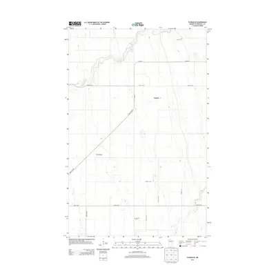
2013 Map of Florian SE
USGS Topo · Published 2013About this map
Middle River winds across the northern landscape of Marshall County, defining a region where the vast agricultural grid of the Red River Valley meets more complex watercourses. The small settlement of Foldahl sits centrally along the north-south axis of Co HWY-3, serving as a local anchor for the surrounding farming community. Historical transit and burial sites are prominent, including the Pembina Trl and Great Eastern road, along with Foldahl Cem and Township Cem. In the southern reaches, the Snake River and the distinctive Swift Coulee break the flat terrain, providing drainage for the sectioned fields. The map documents a meticulously surveyed landscape where modern county highways such as Co HWY-4 follow long-established section lines, maintaining the rural character of this Minnesota prairie region.
Find a feature on this map
15 named features on this map. Tap any name to fly to it.
Don’t see what you’re looking for? This feature index may not catch every label — zoom into the map to look around manually.
Map Details
Editions of this 2013 Florian SE Map
This is the sole edition of this map. No revisions or reprints were ever made.
Other maps of this area

1918 · Angus
USGS Topo · 1:62,500

1918 · Viking
USGS Topo · 1:62,500

1952 · Thief River Falls
USGS Topo · 1:250,000

1956 · Thief River Falls
USGS Topo · 1:250,000

1956 · Florian
USGS Topo · 1:62,500

1957 · Thief River Falls
USGS Topo · 1:250,000

1957 · Newfolden
USGS Topo · 1:62,500

1959 · Viking
USGS Topo · 1:24,000

1961 · Radium
USGS Topo · 1:24,000
1961 · Roan
USGS Topo · 1:24,000