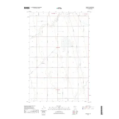
2019 Map of Florian SE
USGS Topo · Published 2019About this map
Middle River meanders across this Marshall County landscape, defining a terrain shaped by the slow-moving waters of the Red River Valley watershed. This 2019 survey captures a rural expanse where the modern road grid, including Co Hwy 4 and Co Hwy 14, intersects with historical corridors like the Pembina Trial. These routes once facilitated the movement of settlers and trade through the northern prairies of Minnesota.
Find a feature on this map
40 named features on this map. Tap any name to fly to it.
Don’t see what you’re looking for? This feature index may not catch every label — zoom into the map to look around manually.
Map Details
Editions of this 2019 Florian SE Map
This is the sole edition of this map. No revisions or reprints were ever made.
Other maps of this area

1918 · Angus
USGS Topo · 1:62,500

1918 · Viking
USGS Topo · 1:62,500

1952 · Thief River Falls
USGS Topo · 1:250,000

1956 · Thief River Falls
USGS Topo · 1:250,000

1956 · Florian
USGS Topo · 1:62,500

1957 · Thief River Falls
USGS Topo · 1:250,000

1957 · Newfolden
USGS Topo · 1:62,500

1959 · Viking
USGS Topo · 1:24,000

1961 · Radium
USGS Topo · 1:24,000
1961 · Roan
USGS Topo · 1:24,000