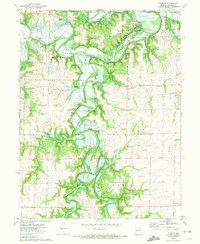
1972 Map of Florida
USGS Topo · Published 1974About this map
The Clarence Cannon Reservoir dominates this 1972 survey, its planned inundation levels marked by blue hatching across the rugged valley of the Salt River. This period of transformation in Monroe County shows the landscape as the dam project was underway, potentially altering many long-standing river features. Near the village of Florida, the Mark Twain State Park occupies the high ground overlooking the confluence of the North Fork Salt River and the Middle Fork. The map documents a blend of rural community life and industry, from the Victor Ch and South Fork Ch to several active Strip Mine operations and a Claypit in the northern hills. Topographic details such as Buzzards Roost and the winding Vaughn Hollow provide a clear view of the terrain before it was reshaped by the rising reservoir waters.
Find a feature on this map
26 named features on this map. Tap any name to fly to it.
Don’t see what you’re looking for? This feature index may not catch every label — zoom into the map to look around manually.
Map Details
Editions of this 1972 Florida Map
This is the sole edition of this map. No revisions or reprints were ever made.
Other maps of this area

1890 · Mexico
USGS Topo · 1:125,000

1903 · Palmyra
USGS Topo · 1:125,000

1945 · Florida
USGS Topo · 1:62,500

1945 · Perry
USGS Topo · 1:62,500

1948 · Quincy
USGS Topo · 1:250,000

1956 · Quincy
USGS Topo · 1:250,000

1959 · Joanna
USGS Topo · 1:24,000
1960 · Goss
USGS Topo · 1:24,000
1960 · Stoutsville
USGS Topo · 1:24,000
1972 · Molino
USGS Topo · 1:24,000