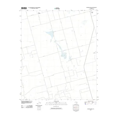
2010 Map of Flower Grove
USGS Topo · Published 2010About this map
Alkali Lake sits at the center of this West Texas landscape, surrounded by a network of rural roads and scattered industrial activity. The settlement of Three Leagues is positioned in the northern portion of the quadrangle, while Flower Grove occupies the northeastern corner. The area’s character is defined by its wide, geometric road grid, including Farm Rd 2002 E and Fm 829, which serve the agricultural and energy interests of Martin County. Grounded in this terrain are the Soda Windmills, reflecting the localized infrastructure necessary for water or power in this arid environment. The map details a transition from traditional ranching or farming layouts to the modern industrial footprints often associated with the Permian Basin’s development in the early twenty-first century.
Find a feature on this map
19 named features on this map. Tap any name to fly to it.
Don’t see what you’re looking for? This feature index may not catch every label — zoom into the map to look around manually.
Map Details
Editions of this 2010 Flower Grove Map
This is the sole edition of this map. No revisions or reprints were ever made.
Other maps of this area

1954 · Hobbs
USGS Topo · 1:250,000

1954 · Big Spring
USGS Topo · 1:250,000

1958 · Big Spring
USGS Topo · 1:250,000

1958 · Hobbs
USGS Topo · 1:250,000

1966 · Wolcott Ranch
USGS Topo · 1:24,000

1966 · Merrick
USGS Topo · 1:24,000

1966 · Lenorah West
USGS Topo · 1:24,000

1966 · Flynt Ranch
USGS Topo · 1:24,000

1966 · Flower Grove
USGS Topo · 1:24,000
1966 · Lenorah East
USGS Topo · 1:24,000