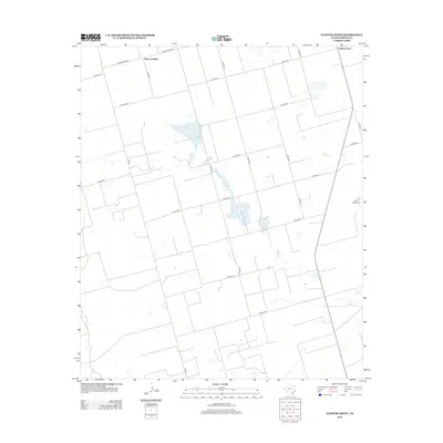
2012 Map of Flower Grove
USGS Topo · Published 2012About this map
The small settlements of Three Leagues and Flower Grove anchor this grid-defined landscape in Martin County, reflecting the agricultural and ranching patterns of the Texas South Plains. The map's geometric road network, consisting of numerous county routes like Co RD-3101 and Co RD-4700, overlays a terrain defined by subtle depressions and mineral-rich basins. The presence of Alkali Lake and localized water sources such as Soda Springs and Sulphur Springs indicate the unique hydrology of the region, where seasonal water and alkaline deposits have historically influenced land use. Soda Windmills further highlights the necessity of tapping underground aquifers to support local homesteads and livestock in this semi-arid environment. Major transit corridors including Ranch Road 2002 and FM-829 provide the primary links between these rural communities and the broader West Texas region.
Find a feature on this map
25 named features on this map. Tap any name to fly to it.
Don’t see what you’re looking for? This feature index may not catch every label — zoom into the map to look around manually.
Map Details
Editions of this 2012 Flower Grove Map
This is the sole edition of this map. No revisions or reprints were ever made.
Other maps of this area

1954 · Hobbs
USGS Topo · 1:250,000

1954 · Big Spring
USGS Topo · 1:250,000

1958 · Big Spring
USGS Topo · 1:250,000

1958 · Hobbs
USGS Topo · 1:250,000

1966 · Wolcott Ranch
USGS Topo · 1:24,000

1966 · Merrick
USGS Topo · 1:24,000

1966 · Lenorah West
USGS Topo · 1:24,000

1966 · Flynt Ranch
USGS Topo · 1:24,000

1966 · Flower Grove
USGS Topo · 1:24,000
1966 · Lenorah East
USGS Topo · 1:24,000