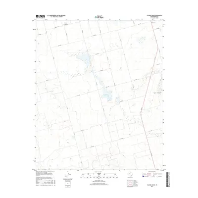
2016 Map of Flower Grove
USGS Topo · Published 2016About this map
Alkali Lake sits as a central focal point in this high plains landscape of Martin County, where the topography is defined by the subtle depression of Sulphur Springs Draw. The 2016 survey documents a rural environment organized by a rigid grid of county roads, with the community of Flower Grove established in the northeastern corner and the settlement of Three Leagues positioned along the northern boundary. The transport network relies on key routes such as Fm 2002, Fm 829, and Farm Rd 2002-E, which connect these dispersed rural centers. The terrain is characterized by numerous small depressions and intermittent water features typical of the Llano Estacado, providing a detailed record of the natural drainage patterns and land divisions in this part of West Texas.
Find a feature on this map
24 named features on this map. Tap any name to fly to it.
Don’t see what you’re looking for? This feature index may not catch every label — zoom into the map to look around manually.
Map Details
Editions of this 2016 Flower Grove Map
This is the sole edition of this map. No revisions or reprints were ever made.
Other maps of this area

1954 · Hobbs
USGS Topo · 1:250,000

1954 · Big Spring
USGS Topo · 1:250,000

1958 · Big Spring
USGS Topo · 1:250,000

1958 · Hobbs
USGS Topo · 1:250,000

1966 · Wolcott Ranch
USGS Topo · 1:24,000

1966 · Merrick
USGS Topo · 1:24,000

1966 · Lenorah West
USGS Topo · 1:24,000

1966 · Flynt Ranch
USGS Topo · 1:24,000

1966 · Flower Grove
USGS Topo · 1:24,000
1966 · Lenorah East
USGS Topo · 1:24,000