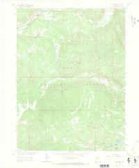
1962 Map of Floyd Peak
USGS Topo · Published 1970About this map
Wapiti Ranch sits as a lonely human outpost in this high-elevation wilderness within the Routt National Forest, mapped just as the 1960s began. The landscape is defined by its complex drainage systems, where the Elk River and its South Fork meet a network of steep canyons and alpine waters. To the south, high-country basins hold a cluster of named water bodies, including Fish Hawk Lake, Lake Margaret, Lake Edward, and Snowstorm Lake, all feeding into the Mad Creek system.
Find a feature on this map
26 named features on this map. Tap any name to fly to it.
Don’t see what you’re looking for? This feature index may not catch every label — zoom into the map to look around manually.
Map Details
Editions of this 1962 Floyd Peak Map
3 editions found
Other maps of this area

1911 · Hahns Peak
USGS Topo · 1:125,000

1913 · Hahns Peak
USGS Topo · 1:125,000

1954 · Craig
USGS Topo · 1:250,000

1955 · Buffalo Pass
USGS Topo · 1:24,000

1955 · Mount Zirkel
USGS Topo · 1:24,000

1955 · Mount Ethel
USGS Topo · 1:24,000

1955 · Mount Ethel
USGS Topo · 1:62,500

1956 · Pearl
USGS Topo · 1:62,500

1957 · Craig
USGS Topo · 1:250,000

1958 · Craig
USGS Topo · 1:250,000