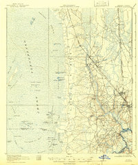
1918 Map of Folkston
USGS Topo · Published 1942About this map
Okeefenokee Swamp dominates the western half of this landscape, its vast prairies and bays defined by numerous islands and local landmarks like the Indian Mound on Floyd Island. The survey highlights the sharp geographic divide created by Trail Ridge, which separates the swamp's interior from the settlement corridors and river drainage to the east. Along the Atlantic Coast Line, several small railroad-focused communities such as Uptonville and Homeland are mapped in detail, showing a clear pattern of development following the rail right-of-way.
Find a feature on this map
70 named features on this map. Tap any name to fly to it.
Don’t see what you’re looking for? This feature index may not catch every label — zoom into the map to look around manually.
Map Details
Editions of this 1918 Folkston Map
3 editions found
Other maps of this area

1917 · Nahunta
USGS Topo · 1:62,500

1917 · Boulogne
USGS Topo · 1:62,500

1917 · Hilliard
USGS Topo · 1:62,500

1918 · Folkston
USGS Topo · 1:62,500

1918 · Moniac
USGS Topo · 1:62,500

1918 · Nahunta
USGS Topo · 1:62,500

1919 · Hilliard
USGS Topo · 1:62,500

1919 · Boulogne
USGS Topo · 1:62,500

1942 · Moniac
USGS Topo · 1:62,500

1946 · Brunswick
USGS Topo · 1:250,000