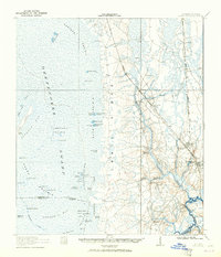
1918 Map of Folkston
USGS Topo · Published 1965About this map
Trail Ridge forms a distinct geomorphic boundary on this sheet, separating the aquatic labyrinth of the Okefenokee Swamp to the west from the settled lowlands of Folkston and Traders Hill to the east. Surveyed during the late 1910s, the map reveals a landscape defined by its wetlands, from the extensive Carters Prairie and Territory Prairie to isolated landmasses like Floyd Island and Indian Island. The Atlantic Coast Line railroad runs north-south through the center, serving as the primary transportation spine for timber and turpentine towns such as Uptonville and Homeland. Along the winding St Marys River, which marks the state line between Georgia and Florida, small rural outposts like Traders Hill School and Prospect Church suggest the dispersed settlement patterns of the South Georgia flatwoods before the expansion of modern highway networks.
Find a feature on this map
69 named features on this map. Tap any name to fly to it.
Don’t see what you’re looking for? This feature index may not catch every label — zoom into the map to look around manually.
Map Details
Editions of this 1918 Folkston Map
3 editions found
Other maps of this area

1917 · Nahunta
USGS Topo · 1:62,500

1917 · Boulogne
USGS Topo · 1:62,500

1917 · Hilliard
USGS Topo · 1:62,500

1918 · Folkston
USGS Topo · 1:62,500

1918 · Moniac
USGS Topo · 1:62,500

1918 · Nahunta
USGS Topo · 1:62,500

1919 · Hilliard
USGS Topo · 1:62,500

1919 · Boulogne
USGS Topo · 1:62,500

1942 · Moniac
USGS Topo · 1:62,500

1946 · Brunswick
USGS Topo · 1:250,000