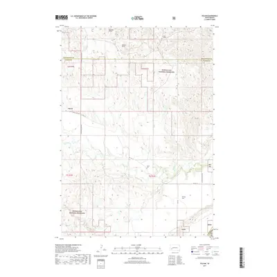
2017 Map of Folsom
USGS Topo · Published 2017About this map
The small settlement of Folsom anchors this portion of Custer County, situated near the winding course of Spring Cr. The landscape transitions from the open stretches of the Buffalo Gap National Grassland to the distinctive elevations of Railroad Buttes in the north. Genealogists and local historians can pinpoint the location of the Folsom Cem, situated southeast of the main settlement area along Co Hwy 121. The map reveals a network of rural routes, including the Lower Spring Creek Rd and Farmingdale-Folsom Rd, which connect the scattered homesteads and ranches across the undulating terrain. Notable geographic markers such as Phiney Flat, Cole Draw, and Elkhorn Draw define the local drainage patterns and provide reference points for land ownership research in this quiet corner of the South Dakota plains.
Find a feature on this map
21 named features on this map. Tap any name to fly to it.
Don’t see what you’re looking for? This feature index may not catch every label — zoom into the map to look around manually.
Map Details
Editions of this 2017 Folsom Map
This is the sole edition of this map. No revisions or reprints were ever made.
Other maps of this area

1951 · Red Shirt
USGS Topo · 1:24,000

1951 · Heutmacher Table
USGS Topo · 1:24,000

1951 · Red Shirt NE
USGS Topo · 1:24,000

1953 · Caputa
USGS Topo · 1:24,000

1953 · Folsom
USGS Topo · 1:24,000

1953 · Caputa NE
USGS Topo · 1:24,000

1953 · Caputa SW
USGS Topo · 1:24,000

1954 · Creston
USGS Topo · 1:24,000

1954 · Scenic SW
USGS Topo · 1:24,000

1955 · Hot Springs
USGS Topo · 1:250,000