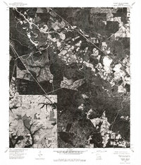
1976 Map of Folsom NE
USGS Topo · Published 1977About this map
Bogue and Chitto form the winding riverine spine of this mid-1970s orthophotoquad, where the landscape is defined by the sharp contrast between dense bottomland timber and clear-cut timber tracts or agricultural fields. The imagery reveals the intricate meanders of the watercourse as it moves through Washington Parish, showing the erosion and deposition patterns typical of the Gulf Coastal Plain. Near the upper-left of the sheet, the small settlement of Enon stands as a focal point for the surrounding rural network of roads and forest lands. Unlike a standard topographic map, this photographic record provides a direct view of the land use in 1976, capturing the specific footprints of timber management and rural habitation that defined the area during this era.
Find a feature on this map
3 named features on this map. Tap any name to fly to it.
Don’t see what you’re looking for? This feature index may not catch every label — zoom into the map to look around manually.
Map Details
Editions of this 1976 Folsom NE Map
This is the sole edition of this map. No revisions or reprints were ever made.
Other maps of this area

1939 · Zona
USGS Topo · 1:31,680

1942 · Onville
USGS Topo · 1:31,680

1942 · Waldheim
USGS Topo · 1:31,680

1942 · Thigpen
USGS Topo · 1:31,680

1942 · Talisheek
USGS Topo · 1:31,680

1942 · Rio
USGS Topo · 1:31,680

1949 · Bogalusa West
USGS Topo · 1:31,680

1950 · Folsom
USGS Topo · 1:31,680

1950 · Franklinton
USGS Topo · 1:31,680

1953 · Mobile
USGS Topo · 1:250,000