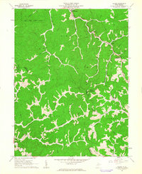
1961 Map of Folsom
USGS Topo · Published 1963About this map
Smithfield and Folsom serve as the primary hubs in this mountainous section of the northern West Virginia coalfields and oil country. The landscape is defined by the heavy presence of oil and gas wells, interconnected by a dense network of pipelines that cross ridges like the Hunting Ground. Following the valley floor, the Baltimore and Ohio Railroad runs alongside South Fork Fishing Creek, supporting the region's industrial output with a Power Plant located near the Folsom bend. The mapping records a rural social fabric of scattered hollows and family landmarks, including the Odd Fellows Cem and several upland congregations such as Fairview Ch and Pisgah Ch. This era shows a complex industrial-rural interface where small settlements like Rinehart and Slabcamp sit adjacent to active Pumping Sta facilities and resource extraction sites.
Find a feature on this map
44 named features on this map. Tap any name to fly to it.
Don’t see what you’re looking for? This feature index may not catch every label — zoom into the map to look around manually.
Map Details
Editions of this 1961 Folsom Map
2 editions found
Other maps of this area

1902 · Clarksburg
USGS Topo · 1:62,500

1903 · Littleton
USGS Topo · 1:62,500

1905 · Mannington
USGS Topo · 1:62,500

1905 · Centerpoint
USGS Topo · 1:62,500

1905 · Littleton
USGS Topo · 1:62,500

1910 · Clarksburg
USGS Topo · 1:62,500

1923 · Mannington
USGS Topo · 1:62,500

1923 · Clarksburg
USGS Topo · 1:62,500

1924 · Centerpoint
USGS Topo · 1:62,500

1924 · Littleton
USGS Topo · 1:62,500