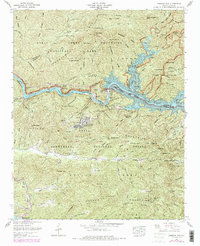
1961 Map of Fontana Dam
USGS Topo · Published 1978About this map
The Tennessee Valley Authority and Geological Survey map the complex landscape of the Little Tennessee River corridor following the mid-century industrialization of the region. Fontana Lake dominates the center of the sheet, held back by the massive Fontana Dam, which reshaped the geography of Graham and Swain counties. Near the dam, Fontana Village serves as a primary settlement hub, accompanied by the Lady Of The Lake Chapel.
Find a feature on this map
69 named features on this map. Tap any name to fly to it.
Don’t see what you’re looking for? This feature index may not catch every label — zoom into the map to look around manually.
Map Details
Editions of this 1961 Fontana Dam Map
4 editions found
Other maps of this area

1886 · Knoxville
USGS Topo · 1:125,000

1892 · Knoxville
USGS Topo · 1:125,000

1894 · Knoxville
USGS Topo · 1:125,000

1895 · Knoxville
USGS Topo · 1:125,000

1901 · Knoxville
USGS Topo · 1:125,000

1933 · Bushnell
USGS Topo · 1:62,500

1935 · Robbinsville
USGS Topo · 1:24,000

1935 · Fontana
USGS Topo · 1:24,000

1935 · Calderwood
USGS Topo · 1:24,000

1935 · Santeetlah Creek
USGS Topo · 1:24,000