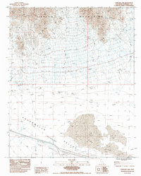
1983 Map of Ford Dry Lake
USGS Topo · Published 1986About this map
The Chuckwalla Valley floor dominates this 1983 topographic study, centered on the stark geological formation of Ford Dry Lake. This arid landscape is defined by the massive (DEPRESSION) that contains the dry lakebed and several scattered Dry Lakes to the east. To the north, the terrain rises sharply into the jagged ridges of the Palen Mountains, which are dissected by a complex network of Dry Washes draining toward the basin floor. Human activity in this desert environment is primarily industrial and infrastructural. A series of underground gas lines, including 3 UG Gas Lines and 1 UG Gas Line, traverse the southern portion of the quadrangle. Significant earth-moving activity is evident near these corridors, marked by multiple Borrow Pits along the valley floor, while access is limited to unimproved tracks like the 5 Jeep trail.
Find a feature on this map
12 named features on this map. Tap any name to fly to it.
Don’t see what you’re looking for? This feature index may not catch every label — zoom into the map to look around manually.
Map Details
Editions of this 1983 Ford Dry Lake Map
2 editions found
Other maps of this area

1942 · Blythe
USGS Topo · 1:250,000

1945 · Midland
USGS Topo · 1:62,500

1952 · Midland
USGS Topo · 1:62,500

1952 · Mc Coy Spring
USGS Topo · 1:62,500

1952 · Sidewinder Well
USGS Topo · 1:62,500

1952 · Palen Mountains
USGS Topo · 1:62,500

1954 · Salton Sea
USGS Topo · 1:250,000

1955 · Salton Sea
USGS Topo · 1:250,000

1959 · Salton Sea
USGS Topo · 1:250,000

1963 · Salton Sea
USGS Topo · 1:250,000