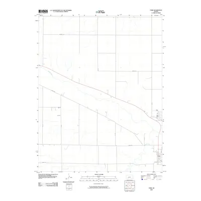
2009 Map of Ford
USGS Topo · Published 2009About this map
The settlement of Ford anchors the southeastern corner of this Ford County landscape, situated where the high plains meet the natural drainage of the Arkansas River. In the early 21st century, the area maintains a strict grid of section-line roads, such as Marshall Rd and Tilman Rd, which delineate the vast agricultural parcels characteristic of southwestern Kansas. The Arkansas River cuts diagonally across the quadrangle, accompanied by Mulberry Creek, which winds through the southern terrain toward the town. These watercourses provide a stark contrast to the straight-edged survey lines, such as Outlaw Rd and Saddle Rd, that define the local transportation network. This survey captures a moment in the region's long history as a cattle and farming hub, where the intersection of Lariat Way and the grid roads continues to facilitate the movement of goods through the expansive plains.
Find a feature on this map
16 named features on this map. Tap any name to fly to it.
Don’t see what you’re looking for? This feature index may not catch every label — zoom into the map to look around manually.
Map Details
Editions of this 2009 Ford Map
This is the sole edition of this map. No revisions or reprints were ever made.
Other maps of this area

1892 · Spearville
USGS Topo · 1:125,000

1894 · Spearville
USGS Topo · 1:125,000

1955 · Pratt
USGS Topo · 1:250,000

1959 · Pratt
USGS Topo · 1:250,000
1969 · Fort Dodge SW
USGS Topo · 1:24,000

1969 · Fort Dodge
USGS Topo · 1:24,000

1969 · Bucklin
USGS Topo · 1:24,000

1969 · Kingsdown
USGS Topo · 1:24,000

1969 · Bucklin NW
USGS Topo · 1:24,000

1969 · Ford
USGS Topo · 1:24,000