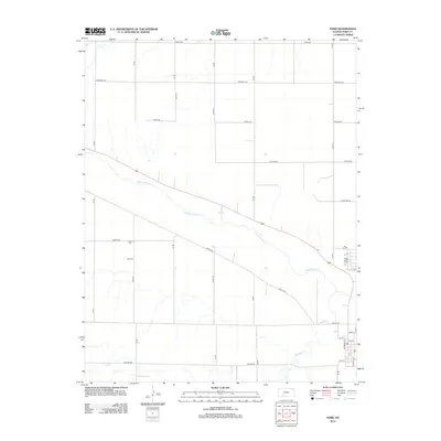
2012 Map of Ford
USGS Topo · Published 2012About this map
The Arkansas River carves a broad valley through this section of Ford County, dictating the regional layout of roads and agricultural tracts. In the southeastern corner, the community of Ford centers on several established streets, including Mulberry St and Prairie St, where a local Po serves as a central landmark near the water. The surrounding landscape is defined by a rigorous grid of section-line roads, such as Nickel Rd and Tillman Rd, which are interrupted by the diagonal paths of Lariat Way and the winding course of Mulberry Cr. To the north, Coon Cr and named routes like Outlaw Rd and Quaker Rd illustrate the intersection of traditional western nomenclature with the structured land management typical of the High Plains. This era of the landscape shows a mature rural infrastructure where small-town life in Ford meets the expansive water-dependent geography of the river valley.
Find a feature on this map
29 named features on this map. Tap any name to fly to it.
Don’t see what you’re looking for? This feature index may not catch every label — zoom into the map to look around manually.
Map Details
Editions of this 2012 Ford Map
This is the sole edition of this map. No revisions or reprints were ever made.
Other maps of this area

1892 · Spearville
USGS Topo · 1:125,000

1894 · Spearville
USGS Topo · 1:125,000

1955 · Pratt
USGS Topo · 1:250,000

1959 · Pratt
USGS Topo · 1:250,000
1969 · Fort Dodge SW
USGS Topo · 1:24,000

1969 · Fort Dodge
USGS Topo · 1:24,000

1969 · Bucklin
USGS Topo · 1:24,000

1969 · Kingsdown
USGS Topo · 1:24,000

1969 · Bucklin NW
USGS Topo · 1:24,000

1969 · Ford
USGS Topo · 1:24,000