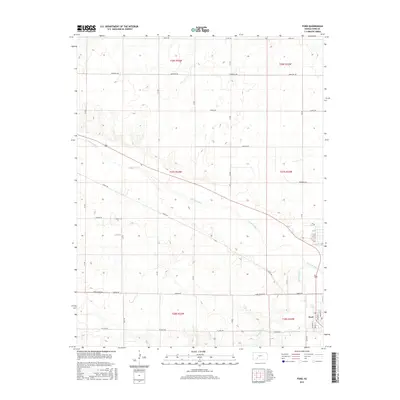
2015 Map of Ford
USGS Topo · Published 2015About this map
Ford serves as the primary settlement on this landscape, positioned where the southern agricultural grid meets the winding course of the Arkansas River. This 2015 survey illustrates a rural environment defined by a rigid section-line road network, including notable routes like Lariat Rd and Ford Ensign Rd that facilitate transit across the wide valley. The river itself creates a distinct diagonal break through the township lines, accompanied by the drainage of Mulberry Cr to the south. Local history is etched into the street names within the town center, such as Walnut St and Main St, while the surrounding prairie is partitioned for large-scale farming. The topography remains relatively level, typical of this portion of Kansas, with the drainage patterns of the Arkansas valley providing the only significant relief to the geometric precision of the land survey.
Find a feature on this map
23 named features on this map. Tap any name to fly to it.
Don’t see what you’re looking for? This feature index may not catch every label — zoom into the map to look around manually.
Map Details
Editions of this 2015 Ford Map
This is the sole edition of this map. No revisions or reprints were ever made.
Other maps of this area

1892 · Spearville
USGS Topo · 1:125,000

1894 · Spearville
USGS Topo · 1:125,000

1955 · Pratt
USGS Topo · 1:250,000

1959 · Pratt
USGS Topo · 1:250,000
1969 · Fort Dodge SW
USGS Topo · 1:24,000

1969 · Fort Dodge
USGS Topo · 1:24,000

1969 · Bucklin
USGS Topo · 1:24,000

1969 · Kingsdown
USGS Topo · 1:24,000

1969 · Bucklin NW
USGS Topo · 1:24,000

1969 · Ford
USGS Topo · 1:24,000