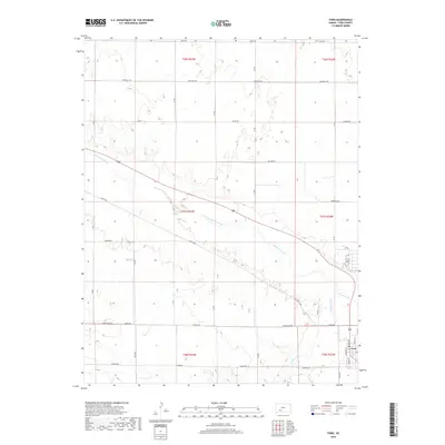
2018 Map of Ford
USGS Topo · Published 2018About this map
The town of Ford serves as the focal point of this Ford County landscape, situated where the high plains meet the riparian corridor of the Arkansas River. This 2018 survey illustrates the geometric precision of the Public Land Survey System, with a grid of rural routes such as Outlaw Rd and Tillman Rd defining the agricultural sections surrounding the settlement. Within the town site, the street plan is clearly delineated by names like Prairie St and Mulberry St, reflecting its identity as a crossroads for local commerce. To the southeast, the terrain is subtly shaped by the path of Mulberry Creek as it approaches its confluence with the Arkansas. The map also records specialized transit routes like Lariat Way and Ford Ensign Rd, which facilitate movement between the expansive farmsteads and the central community.
Find a feature on this map
22 named features on this map. Tap any name to fly to it.
Don’t see what you’re looking for? This feature index may not catch every label — zoom into the map to look around manually.
Map Details
Editions of this 2018 Ford Map
This is the sole edition of this map. No revisions or reprints were ever made.
Other maps of this area

1892 · Spearville
USGS Topo · 1:125,000

1894 · Spearville
USGS Topo · 1:125,000

1955 · Pratt
USGS Topo · 1:250,000

1959 · Pratt
USGS Topo · 1:250,000
1969 · Fort Dodge SW
USGS Topo · 1:24,000

1969 · Fort Dodge
USGS Topo · 1:24,000

1969 · Bucklin
USGS Topo · 1:24,000

1969 · Kingsdown
USGS Topo · 1:24,000

1969 · Bucklin NW
USGS Topo · 1:24,000

1969 · Ford
USGS Topo · 1:24,000