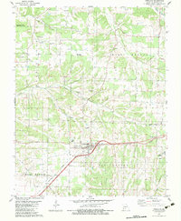
1982 Map of Fordland
USGS Topo · Published 1983About this map
Fordland serves as the primary hub of this Missouri landscape, situated where the Burlington Northern railroad cuts across the rolling terrain of Webster County. The settlement patterns of the early 1980s are clearly defined by a network of rural roads connecting small communities like Compton and numerous local landmarks. Genealogists will find significant value in the distribution of family and community burial grounds, including Mt Olive Cem, Steward Cem, and Zion Cem, which are often located near local houses of worship such as Pleasant Grove Ch.
Find a feature on this map
31 named features on this map. Tap any name to fly to it.
Don’t see what you’re looking for? This feature index may not catch every label — zoom into the map to look around manually.
Map Details
Editions of this 1982 Fordland Map
This is the sole edition of this map. No revisions or reprints were ever made.
Other maps of this area

1884 · Springfield
USGS Topo · 1:125,000

1886 · Springfield
USGS Topo · 1:125,000

1937 · Ozark
USGS Topo · 1:48,000

1939 · Fordland
USGS Topo · 1:62,500

1942 · Fordland
USGS Topo · 1:62,500

1943 · Ozark
USGS Topo · 1:62,500

1945 · Ozark
USGS Topo · 1:62,500

1946 · Niangua
USGS Topo · 1:62,500

1947 · Strafford
USGS Topo · 1:62,500

1948 · Niangua
USGS Topo · 1:62,500