
1963 Map of Fordtran
USGS Topo · Published 1964About this map
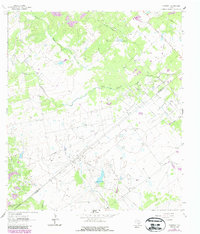
Chicolete Creek and its southern branch wind through a landscape defined by ranching and early petroleum extraction in the mid-1960s. The small settlement of Fordtran sits near the eastern edge of the survey, situated along a decommissioned Railroad Grade that once connected these rural communities. The map captures a high density of industrial activity within the Barry Oil Field and Gohlke Helen Field, where numerous drill holes, pumping stations, and pipelines intersect the traditional agricultural boundaries. Local transportation is facilitated by thoroughfares like Hensley Road and County Line Road, while the numerous Gravel Pits scattered across the terrain indicate the localized extraction of materials for road construction and maintenance. This documentation of the De Witt and Victoria County line reveals a complex network of resource management, from the water flowing through Garcitas Creek to the various gas and oil wells.
Find a feature on this map
16 named features on this map. Tap any name to fly to it.
Don’t see what you’re looking for? This feature index may not catch every label — zoom into the map to look around manually.
Map Details
Editions of this 1963 Fordtran Map
2 editions found
Other maps of this area

1951 · Inez NW
USGS Topo · 1:24,000

1953 · Beeville
USGS Topo · 1:250,000

1953 · Seguin
USGS Topo · 1:250,000

1956 · Beeville
USGS Topo · 1:250,000

1958 · Seguin
USGS Topo · 1:250,000

1960 · Beeville
USGS Topo · 1:250,000

1962 · Verhelle
USGS Topo · 1:24,000

1962 · Edgar
USGS Topo · 1:24,000

1962 · Terryville
USGS Topo · 1:24,000

1963 · Nursery
USGS Topo · 1:24,000