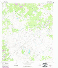
1963 Map of Fordtran
USGS Topo · Published 1987About this map
The Helen Gohlke Oil Field and Barry Oil Field dominate the landscape of the Texas coastal plain along the De Witt and Victoria County line. The map reveals an industrial countryside defined by numerous drill holes, gas wells, and a central Pumping Sta. While much of the area is given over to extraction, the small settlement of Fordtran sits near an Old Railroad Grade, marking a point of transition between the region's agricultural past and its mid-century petroleum economy. Waterways like Chicolete Creek and Garcitas Creek wind through the terrain, with a notable reservoir at Spillway Elev 181. The prevalence of gravel pits and a network of service roads, including Hensley Road, underscores the infrastructure built to support the intensive resource extraction that shaped these counties during the early 1960s.
Find a feature on this map
17 named features on this map. Tap any name to fly to it.
Don’t see what you’re looking for? This feature index may not catch every label — zoom into the map to look around manually.
Map Details
Editions of this 1963 Fordtran Map
2 editions found
Other maps of this area

1951 · Inez NW
USGS Topo · 1:24,000

1953 · Beeville
USGS Topo · 1:250,000

1953 · Seguin
USGS Topo · 1:250,000

1956 · Beeville
USGS Topo · 1:250,000

1958 · Seguin
USGS Topo · 1:250,000

1960 · Beeville
USGS Topo · 1:250,000

1962 · Verhelle
USGS Topo · 1:24,000

1962 · Edgar
USGS Topo · 1:24,000

1962 · Terryville
USGS Topo · 1:24,000

1963 · Fordtran
USGS Topo · 1:24,000